
Panoramio
The Spanish photo map Google bought for Google Earth and closed a decade later, taking millions of geotagged pictures off the map
Panoramio was a geolocated photo-sharing site founded in Spain by Joaquín Cuenca Abela and Eduardo Manchón Aguilar in 2005, whose pictures appeared as a layer in Google Earth. Google bought it in 2007. It grew to tens of millions of photos placed on the map by a large community of landscape photographers. Google announced its closure in 2014, relented after protests, and shut it on 4 November 2016, moving linked photos to Google Maps.
Timeline [edit]
- 2005
-
October 2005
Launch
Panoramio launches
Photos dragged onto a Google Map.
- 2006
-
2006
Feature
Panoramio layer in Google Earth
The blue squares over every landmark.
- 2007
-
30 May 2007
Acquisition
Google announces the acquisition
Completed in July 2007.
- 2010
-
20 January 2010
other
The founders leave Google
- 2014
-
24 September 2014
other
Closure planned, then postponed
Founders and users petition Google.
- 2016
-
7 October 2016
Shutdown announced
Panoramio to close on 4 November 2016
Linked photos to move to Google Maps.
-
4 November 2016
Shutdown
Panoramio closes
Unlinked photos deleted after a year.
How it looked [edit]

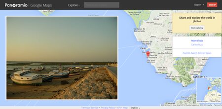
The site through time
Read the old front page here, in one piece, from our own capture: panoramio.com, 29 May 2010 →
Browse panoramio.com as it was, via the Internet Archive's Wayback Machine:
Ownership [edit]
Why it shut down [edit]
Official line: Google announced on 7 October 2016 that Panoramio would close on 4 November 2016 and that users should move their photos to Google Maps and Local Guides; photos from accounts linked to a Google account were carried over, everything else was deleted a year later. Google had first tried to close it in September 2014, when a petition from the founders and users persuaded it to keep the site running for two more years.
Our analysis: Panoramio was acquired for one job, putting good user photos on Google Earth and Google Maps, and it did that job so well that Google eventually decided it wanted the photos without the site. Local Guides and Maps uploads gave Google the same pictures under its own terms; a separate community with its own rules, forums and identity was overhead. What was lost was the archive: a decade of carefully placed landscape photography, much of it from people who never had a Google account.
History [edit]
Photos on the map
Joaquín Cuenca and Eduardo Manchón built Panoramio in the summer of 2005 in Zaragoza, launched it in October, and made a simple thing: upload a photo, drag it onto a Google Map to say where it was taken. Within a year Google Earth had added a Panoramio layer, and the little blue photo squares that appeared over every mountain and cathedral in the world became one of the ways people used Google Earth. On 30 May 2007 Google announced it was buying the company, and the deal closed in July; the founders stayed until January 2010.
Panoramio kept its own community, with monthly photo contests, group discussions and rules that favoured landscape and place over people, and its selection process fed the best pictures to Google Earth and later Google Maps. It reached millions of users and tens of millions of geotagged photos, and for a certain kind of photographer, the one who hikes to a viewpoint and comes back with a panorama, it was the site.
Closed, spared, closed
In September 2014 Google said Panoramio would be folded into Google Maps Views and its photos migrated; the founders and more than 10,000 users signed a petition, and Google backed off, saying it would keep the site going while it worked on the details. Two years later, on 7 October 2016, it announced the end: the site would stop accepting uploads on 4 November 2016, photos from accounts linked to Google would move to Google Maps and appear on the contributor's Local Guides profile, and everything else would be deleted after a year. Panoramio.com went dark on schedule; the layer in Google Earth was replaced by Maps photos, and a good deal of the archive was not carried over.
The domain today
panoramio.com redirects to a Google Maps help page about the shutdown.
Similar projects
 Picasa
Everyone's first photo library
2002–2016
Picasa
Everyone's first photo library
2002–2016
 Everpix
The photo service that solved the problem everyone had and ran out of money anyway, and then published its entire post-mortem for others to learn from
2011–2013
Everpix
The photo service that solved the problem everyone had and ran out of money anyway, and then published its entire post-mortem for others to learn from
2011–2013
 Picnik
The photo editor in your browser, bought by Google and closed two years later
2007–2012
Picnik
The photo editor in your browser, bought by Google and closed two years later
2007–2012
 Photosynth
Microsoft Live Labs' 3D photo stitcher, a jaw-dropping demo in 2006, a website from 2008, switched off in February 2017
2006–2017
Photosynth
Microsoft Live Labs' 3D photo stitcher, a jaw-dropping demo in 2006, a website from 2008, switched off in February 2017
2006–2017
 Inbox by Gmail
Google's attempt to replace its own mail app, loved by the people who used it and closed after four and a half years
2014–2019
Inbox by Gmail
Google's attempt to replace its own mail app, loved by the people who used it and closed after four and a half years
2014–2019
 Justin.tv
One man's life stream that became Twitch
2007–2014
Justin.tv
One man's life stream that became Twitch
2007–2014
Sources [edit]
- Google acquires Panoramio The Register 4 June 2007 [archived]
- Panoramio "very comfortable at Google", co-founder says on way out the door TechCrunch 20 January 2010 [archived]
- Panoramio founders try persuading Google not to kill site CNET 24 September 2014
- Google shuts down Panoramio TechCrunch 7 October 2016 [archived]
- Photo-sharing site Panoramio falls off the map, discontinued in favor of Google Maps Digital Trends 10 October 2016 [archived]
Last verified: 16 August 2026. Spotted an error? Suggest an edit (corrections with sources are reviewed and applied).